

rigger
-
Content Count
2,635 -
Joined
-
Last visited
-
Days Won
5
Content Type
Profiles
Media Demo
Forums
Gallery
Calendar
Store
Posts posted by rigger
-
-
DP I have not raced the Coastal for many years, last race on a young 88, was great fun, so I have no money at risk but I'd like to suggest that those that want to support the club and the 40th anniversary say they will accept a 50% refund with the balance going to cover costs incurred for this year's race, any funds left over to go toward the 40th anniversary race.
I know it would be a huge task for you DP if it happens.
-
 1
1
-
-
On accuracy, just to think about:
Do you know the accuracy of your:
- charts
- sensors / GPS
- Is your GPS antenna position accurate? Does it matter?
The portable systems I'm currently looking after charts are 0.5m position and 0.2m depth, sensors are 0.5m or better.
I doubt there are many recreational systems that have combined accuracy that those portable systems have, mind you cost per system is around the 10k mark, cost of the high density electronic charts was rather expensive, updating costs every 12 to 18months a chunk more.
-
A large number of electronic charts for NZ are accurate to +/-20metres for position.
Take a look here https://iho.int/en/new-guide-on-accuracy-of-depth-information-in-electronic-navigational-charts-encs
Some can be +/- 500metres or worse.
-
1
-
-
Just a few charts here

-
Is the length defined as LoA, LWL, LPB, Register length, sparred length
An example: 22ft boat could be 21ft LWL and have a sparred length of 30ft, an LoA of 23ft....
-
Quite often foreign vessels are ordered out of NZ waters to clean their hulls. In some cases they get divers out to clean the hull of the fouling.
-
What about instead of external storm shutters you had internal ones, a bit like deadlights, if designed properly for strength and ease of use they could serve a dual purpose, mind you no matter how well designed the boat and how good the crew are, there will be a point that the conditions will overcome them....
-
1
-
-
Father in-law had a heart attack at home, mother-in-law caught him as he collapsed, then performed CPR and phoned for ambulance, 15minutes later firetruck arrived followed by an ambulance, fire fighters took over doing CPR, ambos got a defib on him then off to hospital, we were told very small chance of him coming through it without brain damage. 5years on his jokes are as bad as they ever were.
His wife knowing and performing CPR saved his life.
-
1
-
-
Hi folks, was not on that one, was on days off. Been awhile since visiting crew.
A buoy was collected.
Vessel in port
Interesting what a bit of rope can do
-
Tanks on shore full, tankers full at anchor waiting. So the cheap fuel hasn't arrived yet?
Re horses
20 hours ago, Rehabilitated said:You said horses do not need to be registered.
im saying horses do need to be registered.
Search the internet your self and show the law that they do not need to be registered or ask Winnie.
Rehabilitated, horses do not need to be registered unless what you're using them for requires it,
-
Thanks BP,
Also working on one half the diameter.
-
Making a ship's wheel for daughters school. To be part of a play ground.
-
2
-
-
Linz data service, use the crop function to limit download size,
Load file into a suitable app and you get this:
-
Based on info provided it is hard to make a definitive decision.
In answer to your question, did A give enough time, I do not know. The rule say something like, when it becomes apparent to the stand on vessel, unfortunately different people have different limits.
Did B, make a significant alteration to show clearly B was giving way.
Honestly at first glance it looks like A is hunting B down. Rereading the text A is mentioned first as doing an action. If the OP could clarify a the points raised opinions may change, either way, one boat is damaged and as you say we are all repeating the same things.
Last point, Fish you said;
". If the situation is two boats approaching head on, you need to turn to starboard. "
If you are referring to the rule regarding head on situation, that rule applies to power driven vessels, likewise the rule regarding crossing situations.
-
Fish read carefully,
Boat B tacked and once completed was pointing just below Boat A, but now on port.
if from A point of view there is now a risk of collision, think leeway, and it becomes apparent to A that B is not giving way A has to take action...
Boat A started moving to a Broad Reach and Boat B also moved to a Broad Reach.
so A moving to a broad reach first could be considered that action, by B doing the same the risk of collision is re established,
As the boats got closer Boat A beared away as did Boat B. Contact was made and Boat B has a hole at the bow on the port Side.
if A beared away before B because it became apparent to A that B was not giving way, then B is at fault, but if B beared away first so as to give way then A failed to comply as stand on vessel. It really depends on who did what first.
Fish, if the original post read:
Boat B tacked and once completed was pointing just below Boat A, but now on port.
Boat B started moving to a Broad Reach and Boat A then also moved to a Broad Reach.
As the boats got closer Boat B beared away then Boat A did. Contact was made and Boat B has a hole at the bow on the port Side.
Boat A would be at fault.
Fish the rule says
(2) As soon as it becomes apparent to the stand-on vessel that the vessel required to give way is not taking appropriate action in compliance with this Part—
(a) it may take action to avoid collision by its manoeuvre alone;
if B had made a big bear away after tacking it would have been much clearer, after all they were not racing yet.
sequence of events is critical
-
Quotes from part 22
Head-on situation
(1) When two power-driven vessels are meeting on reciprocal or nearly reciprocal courses so as
to involve risk of collision, each must alter its course to starboard so that each passes on the
port side of the other.
And
22.16 Action by give-way vessel
Every vessel which is directed to keep out of the way of another vessel must, so far as
possible, take early and substantial action to keep well clear.
22.17 Action by stand-on vessel
(1) If one of two vessels is to keep out of the way, the other must keep its course and speed.
(2) As soon as it becomes apparent to the stand-on vessel that the vessel required to give way
is not taking appropriate action in compliance with this Part—
(a) it may take action to avoid collision by its manoeuvre alone; and
( b ) if it is a power-driven vessel in a crossing situation, if the circumstances of the case
allow, it must not alter course to port for a vessel on its own port side.
(3) When, from any cause, the stand-on vessel finds itself so close that collision cannot be
avoided by the action of the give-way vessel alone, it must take whatever action will best
avoid collision.
(4) This rule does not relieve the give-way vessel of its obligation to keep out of the way.
~~______________~~end quote~~____________~~
So,
Head on does not apply to vessels under sail
If A altered to dip below B to avoid risk of collision as it became apparent to A that B was not giving way and then B altered and so on then B is at fault......
The avoid altering to port bit is aimed at power driven vessels - see quoted rules above
-
That is the issue Rigger, STCW. The RYA Offshore or Ocean can be commercially endorsed with STCW, by the MCA, UK's maritime national body. Despite maritime nz saying on their website that they will accept stcw certs from the UK, they wont accept this one as its issued by RYA, and only endorsed by the MCA.
RYA issues the CoC which is not an accredited STCW qualification, the STCW endorsement covers the ancillary components that are required for an STCW accredited qualification / CoC to be valid, in other words the RYA qualification is not an STCW cert or CoC, so how can MNZ recognize it as an STCW cert?
I know they accept UK STCW ancillaries for NZ foreign going STCW qualifications.
Simply put The RYA qualification / certificate is not an STCW Cert, it has been endorsed (STCW code A-V1/1 Para 2.1.) to say that the holder has the following:
"Basic training
2 Seafarers employed or engaged in any capacity on board ship on the business of that ship as part of the ship's complement with designated safety or pollution prevention duties in the operation of the ship shall, before being assigned to any shipboard duties:
.1 receive appropriate approved basic training or instruction in:
.1.1 personal survival techniques as set out in table A-VI/1-1,
.1.2 fire prevention and fire-fighting as set out in table A-VI/1-2,
.1.3 elementary first-aid as set out in table A-VI/1-3, and
.1.4 personal safety and social responsibilities as set out in table A-VI/1-4."
The RYA website says:
"Non British flagged vessels
If you are working on board a non-British boat, your RYA certificates are likely to be acceptable but you will need to comply with the rules of the flag state"
Likely? they could have a list of countries.
If you have an RYA Cert that is commercially endorsed with the STCW Basics, and you want to convert to an NZ CoC, there might be a way, I'm not talking recognition by MNZ by the way.
Apologies for the wordiness
-
There a number of qualifications in NZ,unfortunately to be recognized internationally a qualification has to comply with STCW.
Below is one
https://www.maritimenz.govt.nz/commercial/certification/masters-and-deck/master-yacht.asp
"With this certificate, you can perform the functions and duties of master on a superyacht of less than 3000 gross tonnage (GT) in any operating area. A superyacht is a commercial yacht or sail training vessel that is 24 metres or more in length, less than 3000GT and does not carry cargo or more than 12 passengers.
This is the highest-level command certificate for superyachts. To command any other type of vessel you must obtain the appropriate certificate."
A course in NZ for the above
There are a few companies I know that deliver small vessels around the world, they only employee people with STCW tickets, some of the skippers have tickets for under3000GT but a couple have
-
Cost up your time, fuel, etc versus new anchor.
One anchor I recovered had no chain on it so it can be done, it was tricky getting it on deck. But then snagging a 15tonne anchor with a 2 tonne grapnel was unlikely so getting it on deck was not really considered. An interesting exercise it was....
-
Last trip my flares expired a week before I left. I didn't replace them as I knew I would be 2-3 years before I went again.
Flares with a max of 4years rather than 3years can be bought now.
-
Hi Troy
That one is captured by length, and by a clause of the MTA1994 allowing the Director (MNZ) to require any vessel to carry a pilot. This power is often delegates to the Harbourmaster.
In my case I have only used it for some foreign fishing vessels where the master had very very limited English this was unable to effectively communicate, report, and understand requirements of navigating in the harbour.
Long time since we sailed on the spirit together. Maybe catch up with you in sunny Tauranga some time.
Cheers
Jim
Thanks Jim, drop by if you like, avos are ready to pick.
-
The 500 get is about the requirement to carry a pilot. For Auckland any vessel 500grt or more, or 40m loa or more, must vary a pilot regardless of whether they are commercial or not. There is the ability to be become a pilot exempt master for a specific port, vessel and berth/wharf but most exemption training schemes require you to have a commercial masters ticket regardless of whether the vessel is commercial or not. 39.99m is fine 40.00 m and you are caught or time to get the saw out....
few others:
Tauranga is 250gt or more
Bluff 100gt or more
Nelson 40m or more
Go to https://www.maritimenz.govt.nz/rules/part-90/ for full listing.
Elenya, if a vessel is built and has no tonnage cert and is not assigned a GT and the port has no length limit then I take it no pilot required?
-
Flying fish, 18 inches long, make a thump when hitting hull.
-
Auto inflating life jacket, auto plb, AIS MOB device all linked to an electronic tether to the vessel, vessel signal lost (short range say 100m),audible alert and light to alert wearer, if false alert, the wearer can stop the gear being triggered otherwise the LJ and other linked devices are triggered.
Possible system or to techo?

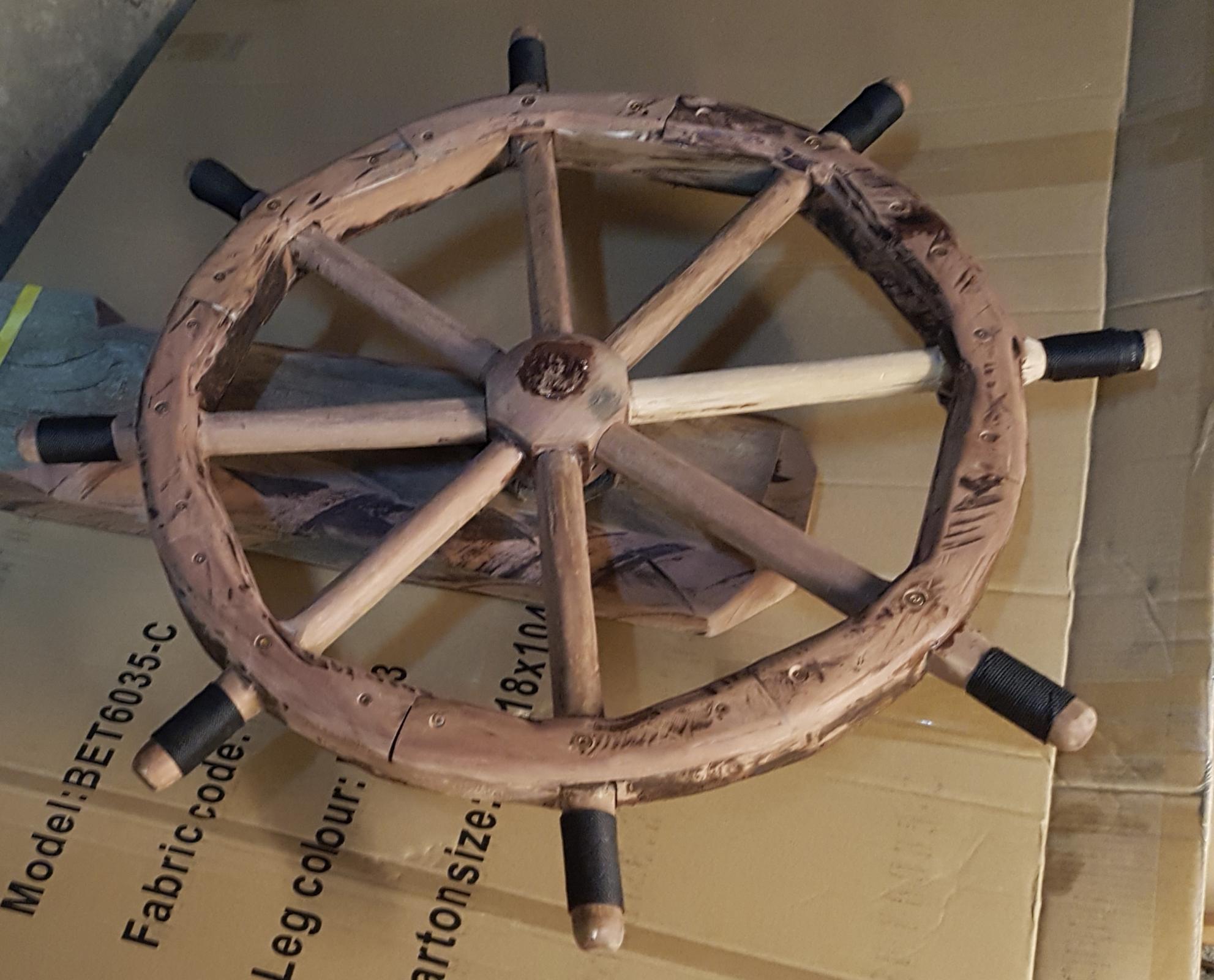
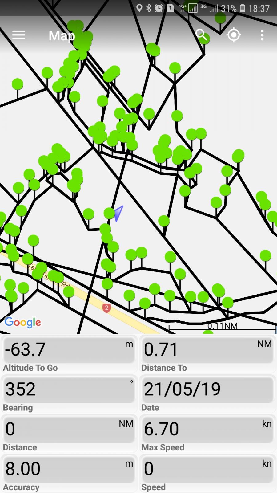
Photo caption competition
in MarineTalk
Posted
Failed attempt to go outside the environment.