


MuzzaB
-
Content Count
113 -
Joined
-
Last visited
-
Days Won
2
Content Type
Profiles
Media Demo
Forums
Gallery
Calendar
Store
Posts posted by MuzzaB
-
-
11 hours ago, Hapuka said:
Actually beg to differ, although true some Farr's race boats looked pretty "functional", I always thought Ceramco was a really pretty boat, The 1020 and 1220 are both good looking girls and you cant say a Farr 38 hasnt got sleek and racey lines?? (bit biased as I'm now a farr 38 owner). And what about the newer Farr 395?
Yes. I think they would be on my list of exceptions too, especially Ceramco; always thought she was good looking. It was more the late IOR boats I was referring to. He had some really successful designs in that era and they won a lot of races, it just happened they were not pretty to my eye. Exador was a true champion but I don't think she wins a beauty contest.
But then looks were not the objective of the design. Getting the best from the IOR rule was.
But that is just my eye and we digress.
")
-
I can't comment on the maintenance issues because the boats my family owned and my subsequent boats were a lot younger than these boats are now. But I can comment on the sailing and cruising qualities of the Raven, Tracker and the Reactor. My family had a Raven around the late '70s/early 80s. I had two Reactors at different times (and raced couple of others), and did a lot of racing (and cruising in company) on/with a friend's Tracker.
I would echo what has been said about the Raven. If you can get past the looks, they offer significant space below for their length, are a very dry boat to sail, handle beautifully and are a great sea boat. They have a couple of "features" - not problems, just functions of the design. As a slack bilged hull they tend to take up a few degrees of heel when at anchor or on a mooring in a strong wind. The high deck forward caused the boat to sometimes "hunt" on its anchor in a breeze. These features are of course totally unimportant. Great boats if in good condition.
The Tracker is, on average, just a little quicker but this is unimportant for cruising. We had a lot of fun with the Tracker and they are good boats too. Not quite as much room below as the Raven. Alan Wright limited the beam to 8'2"/2.5m so they could be put on a trailer within standard limits. The Raven beam is 8'9"/2.7m. The Tracker is a little lighter (though certainly not light by modern standards) and so a little more lively in a seaway.
I agree with Sabre's comment re outboards. When the going gets tough, being able to motor to windward or motor/sail while keeping the propeller in the water keeps a nervous family and young children happy.
The Reactor has not been mentioned in the other posts but is a boat of similar length and age. It is my favourite of the three, but is also the one with the least interior volume and (arguably) the slowest too - by just a little. It is my choice as a pocket offshore cruiser, but as that is not on the cards for you, the Raven - or Tracker - would be a better and roomier choice.
-
I have never sailed a Shiraz though I always thought they looked like a reasonable cruising boat.
I have sailed a Lotus 10.6 offshore including an extended period on the wind in breezes up to force 7 (as is quite common on a return from the Pacific Islands). It was not a happy experience though in large part this was due to the owner's incomplete preparation of the boat rather than a fundamental problem with the design.
The cockpit was not conducive to comfort and easy working when sailing to windward for an extended period with a decent sea running. None of this was insurmountable with a little modification. With boats that are broad across the cockpit I have a preference for well placed braces for feet, well thought-out anchor points for harnesses, and a layout that allows a crew to work the boat when heeled without expending unnecessary effort to keep themselves in the right place or at the right angle to winches, clutches etc. The Lotus 10.6 cockpit (at least the one I sailed) is great for cocktails in a quiet bay, but not so great for 48 hours on the wind in a seaway. But then I have been spoiled and lucky to sail on boats that have been very well thought-out for offshore racing and passages, both on deck and below.
I have a dislike for large cabin windows offshore, and for large volume cockpits that are not set up for rapid draining at any angle of heel. I also don't like cabins without thought put into how far the crew below may fall in a knockdown, or just while moving through the cabin in a big sea, and how to reduce risks associated with that. The Lotus 10.6 suffered on all counts, but again this could be remedied if an owner planned regular offshore work. Other problems we had (leaky foredeck hatch, broken halyards, unsecure storage below) were nothing to do with the boat and all about preparation. We also had difficulty removing such water as we had below - primarily as a result of a leaking forward hatch. The result was water up the interior of the boat which, when heeled for extended periods, soaked the contents in lockers - in conditions which, while feisty, were quite common and not at all dangerous. Again this can be rectified with some work on the interior and sensible bilge pump installation - and may not be a problem at all in other boats of this design. The boat I sailed was finished by the owner who was neither a boat builder nor experienced offshore.
I came away from that trip thinking that the Lotus 10.6 was a fine boat for the Gulf, but would not be my choice for offshore. That said, we did enjoy some very pleasant reaching.
I'm not saying that the design should not be taken offshore. What Kerry Dobbs achieved in Kirsten J (the smaller Lotus 9.2, which is very similar in concept) is legendary.
-
 1
1
-
-
9 hours ago, marinheiro said:
it was a bandwidth issue
Bandwidth was in part what I meant when I mentioned inefficiency. The other aspect was the antenna required for efficient transmission; typically a backstay antenna with insulators. The short whip antenna for the VHF 2m band was/is simpler and an easy option for powerboats and launches. On my last boat in N.Z. I didn't bother with a masthead VHF antenna, and just used a whip antenna at the stern mounted a little over 2 meters high. That was enough to give full coverage across my cruising range between the BoI and Mercury Bay thanks to the repeaters on high points of land.
HAM operators (I am one) use both LSB and USB; typically LSB at 7 MHz and below and USB above that. So the common HAM maritime net frequency of 14.3 MHz uses USB.
Interestingly, given the other thread discussing the recent rescue off Bream Bay, our VHF came in handy not long after they were introduced to N.Z. Sailing south from the BoI we were a few miles off Bland Bay when we saw a smoke flare maybe 3-4 miles away. We could see the smoke but not the boat. At 5 knots under either sail or power it was going to take us well over 30 minutes to get there. It was the only time I have ever called mayday. A fast launch near Oakura heard the call. We were able to give him an EP for the flare and he got to the distressed boat a few minutes before we did. I believe that response time would have been slower if, these days, a boat had relied on a cellphone rather than the ability to put out an "all stations" call.
The "victim" was a plywood fizz-boat; one of those Frank Pelin (or similar) designs that were common as home-built boats during the 60s and 70s. It had come off the top of a wave at speed and split the hull open. When we got there it was totally swamped with four people in the water.
-
It may interest the younger folk and amuse the older folk that we have just passed the 45th anniversary of the introduction of Marine VHF radio in New Zealand.
The New Zealand Post Office - which is those days administered all things radio, including licences and examinations, introduced the service in April 1976.
Initially coverage was provided for Auckland and the Hauraki Gulf via Auckland Radio ZLD (with transmitters at Musick Point, Motutapu and on the Coromandel), Wellington and Mana/Cook Strait via Wellington Radio ZLW, and in Tauranga via the Tauranga Harbour Board. Services were provided via channel 16 and 68 or 71 only. These comprised listening (ch 16), weather forecasts on one of the working channels, and the taking of emergency and telegraph traffic.
If you were a club or organization wanting a shore station, you needed to apply to the Post Office. There was an initial fee of $35 and a bi-monthly fee of $15.85. For boats the annual license fee was $16.
There were few VHF radios available in New Zealand at that point, though one was the ICOM M25, which was a fully functional 25 watt set. ICOM still uses the M25 designation today - now as a 5W handheld.
Prior to this, many of us had inefficient AM/DSB transceivers, the simplest of which could only transmit on 2182 kHz but could receive on 2207 kHz (for weather). If you sailed further afield you probably had one of the SSB sets available at the time. These were crystal sets and so covered a selection of fixed frequencies across the available bands usually either 6 or 10 frequencies to cover the emergency and working frequencies of choice. The most common transceivers for pleasure boats were built in Australia or New Zealand and had between 30 watts and 150 watts PEP depending on your needs and how much money you had to spend.
Of course the coverage and nature of VHF services expanded rapidly, as did the choice of radios.
-
 1
1
-
-
20 minutes ago, waikiore said:
Strangely the articles back in the day all refer to the New Golden Hind as a schooner whereas the pics all show a ketch!
There is an article in one of the newspapers (can't remember which) published in '37 or '38 when she (New Golden Hind) was under construction and which described the intended rig as a schooner. I speculate that this may have been the intention, but that the rig plan was changed before completion.
-
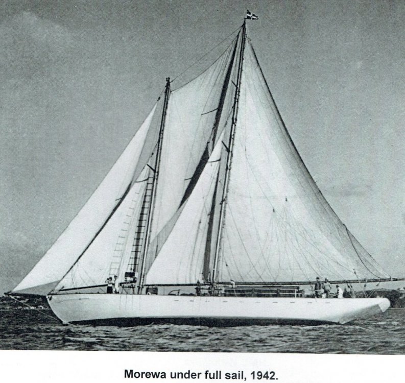
BTW, I suspect the schooner in the other photo - identified on Waitemata Woodies based on how it is recorded in the Auckland Library, is also Morewa. I have found that as online sources of photographic history increase, and time passes by, the misidentification of a photo, as to subject or date, is common. Over the years I have provided suggested amendments to NatLib, Auckland Library, Alexander Turnbill etc together, with evidence where I have it. Sometimes they make the change - sometimes they don't.
There was one online library source - which shall remain nameless but is in the central North Island, which described almost every sailing dinghy in its photo records as a "P Class".
-
The photo of the Centaurus and the Samoan Clipper together was taken on December 28 or 29, 1937.
The New Golden Hind was not launched until 1939 (I think). I believe she was always ketch rigged.
I'd suggest the most likely candidate is Morewa, which was owned at the time by Sir Ernest Davis, who was mayor of Auckland at the time the photo of the flying boats was taken.
Here she is (from this source... https://rnzncomms.org/ngapona-newsletter-3/ )
-
That rings bells. Andrew Taylor. Could be.
I seem to remember a young Rohan Lord sailing an FA at Howick too, by which time I was in a Starling or maybe a Europe - but that would have been a couple of years later.
-
Just for fun.
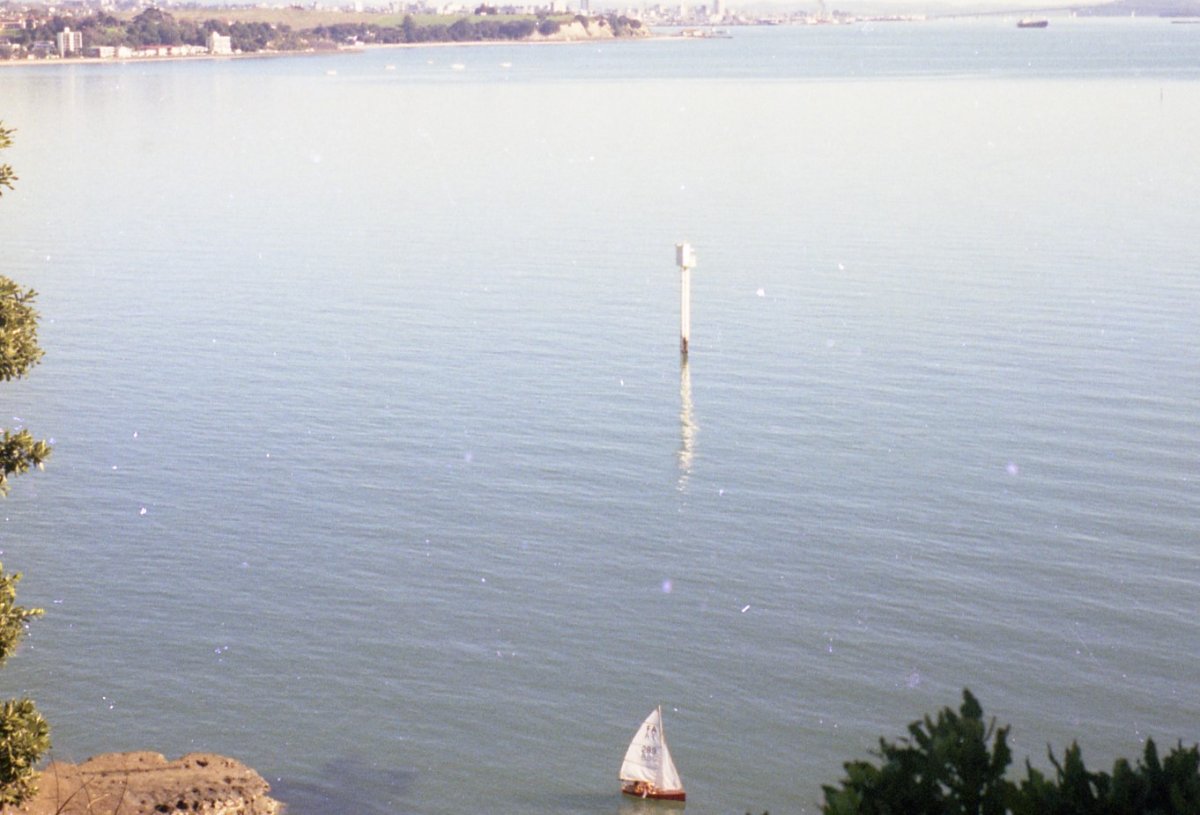
In my ongoing quest to scan and archive hundreds of old photos I came across a snapshot of Auckland I took from Musick Point in 1977. In the bottom of the photo there happened to be a Flying Ant, sail number 289. Attached is an extracted enlargement - but still fuzzy and small. I may have known who it was at the time, but have no clue now. I know some others here on Crew used to sail FAs as a kid (as did I). Anyone recognize the sail number? My guess is that it was part of the Glendowie fleet which was reasonably strong at the time.

-
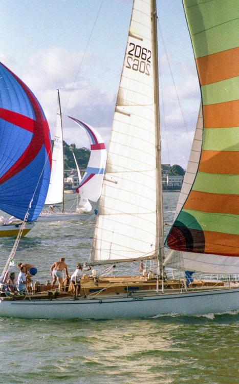
3 hours ago, marinheiro said:
Then there was Jipcho, 41' which was used as the plug for the Young 43 centre cockpit (I guess there must have been a temporary extension to develop the Y43's transom).
All very similar in design concept
Here is Jipcho at the start of the White Island Race in 1981. Ants and Epiglass NZ also in the picture.
-
2 hours ago, Tamure said:
Interesting seeing it from a US perspective as an "antique sailboat" Namu just retired from Squadron racing this year after 50 years of racing in westhaven, moreover it was pretty much the winning boat in its division.
Part of it is realizing that many of us are now also a little "antique". Sometimes it comes as a shock.
Because I started keelboat racing as a young nipper on the foredeck from both ends of the harbour, I raced against Namu and some other EnZed Thirty-Sevens (I'm not totally American) when they were still relatively young (excuse the pun). Nemesis and Notre Dame were active at the city end, and Amber at Bucklands Beach. Several others here on Crew did the same (as already noted). Many of the boats of that era which were competive at Richmond, Squadron, Akarana, Bucklands Beach an others are now on the register of the Classic Yacht Association of New Zealand. So realism sets in.
It is great to see these boats in good condition. My heart sinks when I see a boat I used to know years ago in a condition today which is beyond economic repair.
I think the basic hull shape of the NZ37 is still fast. Jim Young once told me (circa 1986 I think) that he didn't think hull design had changed much over the years, but that designers designed boats that were capable of being built and rigged with the technology available at the time. You couldn't build a Rocket 31 in 1966 with the materials and technology available at the time (he said) but that he would have if he could. What he was meaning by this was that he designed to a displacement that could be built and with a rig that could be made to stand up and sails that worked when made of the sail cloth of the time. Much of the development (he said) was in the rig, sail materials, appendages and hull materials. It was the 1980s, but even now his observation makes a lot of sense, though obviously hull shapes have evolved beyond a mere reduction in displacement.
I think if I took the NZ37 hull design and tweaked it a little for new appendages, deck, cabin, cockpit and new rig that would still be a very modern boat.
-
2
-
-
Scot Tempesta has posted his video of the NZ 37.
-
1
-
1
-
-
17 hours ago, chariot said:
I thought the Harmonic was a 24 ftr
There was a Harmonic 33. The only thing it had in common with the 24 was that it was built for and marketed by Compass Yachts. I don't think many were built.
I remember Saint Stefan but like Wiakiore I thought she was a C&C although I seem to recall the coachroof was a little different from the standard C&C 33.
Fading memories.
-
1 hour ago, muzled said:
Does anyone know what that exclusion zone is out of the Galician coast?
It is a shipping traffic separation zone, entry to which is prohibited for the VG competitors.
Edit - looks like you got two answers (the same) within a minute
-
1
-
-
Very sad and surprised. I never knew him well, but sailed against him in dinghies and to some extent in bigger boats.
-
Although I have enjoyed sailing on various Farr designs over the years I have never thought of his boats as particularly pretty. Jasmine however was one of the exceptions. her original hull colour was - as the name suggests - pale yellow. That might seem an unusual hull colour these days, but it worked.
-
3 hours ago, Fish said:
Tracker says he's doing 2.9 knts @ 141 degs, but it s dated 14th.
The date follows UT (old GMT). As I post this we are at 2335h UT so about to roll over to the 15th.
Getting that wrong was a common mistake back in the days of celestial nav.
[Edit to fix stupid stupid stupid spelling].
-
3 hours ago, Island Time said:
Used to have one of those when I was a kid. They were riveted together, and after many years of being trashed, it leaked pretty badly thru the rivets. To use one as a tender, you'd want to have some pretty good gunnel fenders, and have to have a careful think about how to get aboard without trashing the mother ship. The alloy can leave nasty marks, dents and scrapes. But, on the other hand, they are light and tough
We used the 8'6" Parkercraft as a tender for a while when I was a kid. I think my father's thinking at the time was that the boys couldn't do too much damage to it. We installed a pretty good PVC gunnel strip. With a 4hp outboard that thing would fly, but it was terrible to tow in a crosswind and did not track well. It was as ugly as...
The image of the Townson reminded me of the tradition Squadron dinghies: not glued clinker but the old clinker brass-riveted over bent frames. When I was a wee nipper some family friends had Tawera. When they sold her they kept her dinghy, which may well have been a Logan like the boat it belonged to. It was such a piece of art. I wish I knew what happened to it.
Sorting through some photos the other day I came across a photo taken at Roberton Island during our summer cruise of either '82 or '83. Almost all of the dinghies on the beach are rigid dinghies. We had one of the Jim Young dinghies by then (built it from a kit) and it was a sweet dinghy though a little unstable when boarding. Today the beach would be full of RIBs and inflatables.
BP - I'm glad you are considering a rigid dinghy. To keep the spars to a length where they can fit inside the boat, how about a lugsail? I am currently rebuilding an El Toro pram dinghy (very Northern California - but essentially the same as the Sabots that used to sail at Wakatere). Instead of its original mainsail I am converting it to a lugsail so that the spars can fit inside the hull. It will be a tender. The same would work well on a boat of 11 or 12 feet. But for rowing efficiency in a fixed-seat you would want to stay as close to 4' beam (1.22m) as possible. The Sunburst is 4'11" which requires longer oars and more effort (as you know).
I'll be happy to build to order - but you have to come to San Francisco to collect it and let me do the return trip.
")
-
Slocum used a sextant and tables. He even claimed to have used the lunar distance method to determine longitude though this may have been more of a tall story.
Slocum took regular meridian passage sights but may have relied on DR more than he let on for longitude.
-
Thanks for the kind words Kevin.
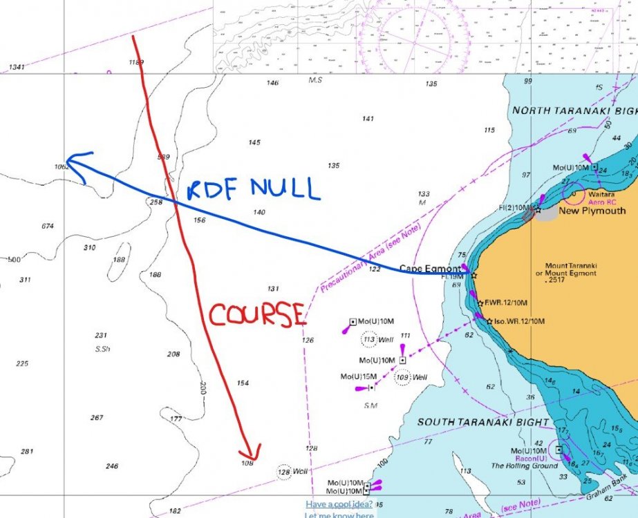
BP, to your point, I recall an approach to the Cook Strait area from the Tasman in the days before Sat Nav and GPS. The weather had closed in and the wind was fresh from the south west. I had no sextant sight for 24 hours and we had not seen land. We were still north of Cape Egmont.
Over the space of about 30 minutes there was a very noticeable change in the waves and the motion of the boat. One of the crew even had a little panic because he had not experienced this before and convinced himself we were about to run ashore. Our DR coincided with the rapid reduction in ocean depth as shown on the chart, but we only had a simple depth sounder on board which was useless at those depths. This was still the days of RDF and Cape Egmont broadcast a good signal. I had a B&G Homer RDF and headphones and got a good null off Cape Egmont. The position line from the RDF passed close enough to the DR position to give me comfort that we were crossing the shelf and experiencing the sea change from the rapid change in depth. This was at about the spot shown on my crudely drawn attachment. RDF signals are more subject to a polarization error at night (and it was night) so I was a tad concerned, but the ducks seemed to be in a row.
Now we just look at the chart plotter - but the old tricks still work.
-
Some facts:
He rounded Cape Horn without hitting it.
Cape Horn lies at 55 degrees 59 minutes S.
He had charts.
He had a sandglass.
He didn't see land during the rounding.
He estimated his latitude at rounding to be 56.9S, in round numbers, one degree of latitude (60NM) south of the cape.
Reasonable assumption: He knew his boat and was able to estimate speed through the water - he may even have been using a traditional log line, which would have been consistent with his navigation approach.
He wasn't racing, so his course would have been considerably north of the cape until it was necessary to get south and around it. You will not be aiming to make landfall at the cape but you DO want to make landfall before you approach Cape Horn. But, with prevailing westerly winds that can be dangerously strong, you do not want to get closer to the coast than you have to.
There is a peak of about 1,700 feet (518m) 16 NM north of the cape. 7 NM north of the cape is a 1,000 foot peak. The cape itself is not high, and the land immediately to the north does not exceed 500 feet.
So starting with Cape Horn and in ideal conditions, and assuming an eye 10 feet above the waterline, these points of land might be seen 36 miles south, 35 miles south and 30 miles south respectively. In other words from the south you would see land behind the cape before you see the cape itself. From 60 miles south of the cape you would need land of around 2,500 feet in elevation to see it in perfect conditions - and there is none. However there is plenty of land of that altitude and higher around Isla Thomas (and not far inland), 89 NM north west of Cape Horn. What does this mean? You cannot rely on seeing land from a safe distance off when rounding Cape Horn, even in the event you get ideal weather. Without accurate navigation, you need a good fix off the land north of Cape Horn before you put sea room between your boat and the cape itself. Because you cannot rely on good weather, you need a period of time - perhaps a week - in advance of rounding Cape Horn - to establish your position well north of the cape by reference to high points on the land.
Now speculation:
You need to round Cape Horn without GPS, sextant, compass, weather forecasts etc and you are in a small boat. You are going to want two things - plenty of sea room and a good departure fix. (You young folk may have to look that one up). You will make landfall something like 600 NM north of the cape, and the coast at that point is also considerably west of the cape. Assuming perhaps 120 miles a day or less, you will keep the coast at a safe distance and approach - weather permitting - only close enough to make observations of high land until you believe you have correctly identified that land. This is done primarily by reference to height above sea level on the chart and sufficient observations of points of high land over a couple of days to achieve a match on the chart as you sail south.
You now have a fix as to latitude and, by observation of loss of a high point below the horizon (in good weather) you also have distance off (approximate - because you have to estimate the bearing). This is a fix - with errors but a fix nonetheless.
You then continue to proceed down the coast - with the land in sight intermittently depending on the weather. There be mountains here - so in good visibility the high points can be seen well out to sea, where they appear as distant "islands" above the horizon. From the chart you have an expectation of which high points will be seen, and when they are seen, you use these to update your position. Again - you approach closer to the land when the weather permits but probably never closer than an estimated 30 NM. There are probably extended periods with no horizon and clouds down to almost sea level, so patience is needed and frustration is certain. You may heave-to at night if safely offshore, or sail a reciprocal track so that you can confirm a high piece of land with a second or third look.
Over three days you have comfort that you have a reasonable position and track. Now you need sea room and you need to get south. You abandon any sight of land and note your final departure fix. Perhaps this uses the snow covered mountain peaks around Isla Thomas if the weather is good. Your plan is simple, by DR and steering by the waves, sun and stars you run due south if the wind allows. You log your estimated speed through the water every hour or so, and you adjust for currents (noted on the charts) and estimated leeway. Using your departure fix as your starting point and your DR track you note when you believe you are at about 56S (approximate latitude of Cape Horn) and judge that you want one degree of latitude between you and the Horn. You continue to sail, time and distance, until you believe you have run a further 60 miles south.
You turn to port and attempt to maintain the same latitude until you believe you have passed the Horn.
So your plan is to pass the Horn at 57S, using DR from a fix about 24 hours old. You continue to update your DR track and for whatever reason estimate some northing and note 59.9S in your log.
Years later, this log entry is quoted in an obituary.
I don't see purple prose or trickery here. I see logic. This is much the same as coming back from the Islands and planning a landfall at Cape Brett even if the destination is Auckland. In the days before Transit, and then GPS, we always aimed at high land in order to have the best chance of establishing a position line from the coast before we got close.
-
Yes. 1976 OSTAR. Innovator of Mana was a custom Nova 28, flush decked.
-
I sailed and raced with Jim decades ago. His contribution to N.Z. sailing will not be forgotten. He was never afraid to be radical in his designs.


Navigational Warnings
in MarineTalk
Posted
Outside of Motukaraka Island (or Flat Island as I always knew it) at Beachlands. I believe it is Dennis Rock (2 "n"s) on the chart.