


Fish
-
Content Count
5,353 -
Joined
-
Last visited
-
Days Won
158
Content Type
Profiles
Media Demo
Forums
Gallery
Calendar
Store
Posts posted by Fish
-
-
10 minutes ago, Black Panther said:
Expecting a warning system for one tiny location is unrealistic.
Utilizing a system that alerts the entire population because a few boats might get damaged is irresponsible.
Saying there is no threat when there is a threat is a bit irresponsible also.
-
2 hours ago, Zozza said:
Via text Pscyhe, just like we got from the Govt for the Covid lockdowns etc
I think the media are indeed all over it now, but the point is, before hand, people were told the threat had passed, then Tutukaka promptly got smashed.This is the key part. The rest is just a distraction.
The system / govt issued a warning after the damage occurred. About as useful as tits on a bull...
-
 1
1
-
-
2 hours ago, Psyche said:
What should we expect though, sirens, loudspeakers? Maybe in very busy areas but unworkable in most places, we used to have radio when everyone listened but thats going the way of the dodo. How about a civil defence text message, seems pretty simple.
No, the problem is they said there was "No Threat". That was the first statement. I read it at about 7:30 pm, turned the internet off, watch some TV and went to bed. Many people did the same, NZ escaped loss of life by good luck, not good management. Gulf Harbour had the eastern seawall over-topped and a surge go up the marina, but it was dead low tide. If it were high tide, the outcome could have been different (the good luck part). Clearly anyone sleeping on their boats are at risk if the boats get capsized in a marina in the middle of the night...
Clearly there was a threat. They said there wasn't. They may have updated that later, but I saw the 'no threat' statement and didn't check again. Maybe I was misguided to have faith in our govt warning systems?
-
48 minutes ago, Black Panther said:
sh*t. We're away from the boat(celebrating 34th anniversary), won't be back till this evening. Booboo if you see her drifting past run out and kick the anchor over will ya?
I'm going down in a moment to do some maintenance. If she's not there, I'll nick your mooring with my boat
")
PS, actually, maybe not, if she's not there it means you probably had sh*t mooring lines and they failed, I'd be far happier with my own.
-
Why there should have been an alert, from stuff:
Northland fishers ran for their lives in tsunami surge
A group of people fishing in Hokianga Harbour on Northland’s west coast early Sunday morning had to run for their lives as tsunami water surged up to their waists.
Local Lili Mullane said the group went down to the water near the northern harbour entrance at about midnight to go floundering, a common activity on the weekends.
They had heard of a tsunami advisory following the Tongan eruption, but believed it was only for the east coast and that the threat had lifted, she said.
Mullane said the first sign of any trouble was an unusual reaction from the wild horses in the area, which suddenly started stomping and running away.
“Next minute the water started going out … It went out about 50m and it was dry all around and all I remember was [a friend] Christy saying to me, ‘run’.
“Within minutes, the water came up to our waists,” she said.
“I wondered how deep it was going to get - in the dark you get a little bit confused. We had torches and headlamps but all I could see was water all around me and we just ran.”
Mullane said her friend Christy was particularly scared.
The fishing group managed to get to shore, where more friends in a ute were waiting for them, with water “gushing” all around them.
They drove through water nearly 1m deep, going onto private farms to get away, and managed to escape unharmed.
But Mullane said she can still see the tidal surges coming in and out of the harbour every 20 minutes.
“I’m not going near the water .. right now I want to stay away from it.” -
1 hour ago, ballystick said:
3 am? Did you get a notification?? I heard nothing, in the past we have heaps of warnings but nothing this time??
After seeing the news reports of tsunami in Tonga, there was a statement saying no tsunami threat in NZ.
I watched some TV and went to bed. Wake up this morning and the most damage there has ever been from a Tsunami... After there has been damage they issue a warning...
saying I can't go windsurfing or surfing today (and its a cracking day)...
The system has no credibility.
At the very least they could have issued an alert saying 'something has happened - watch for warnings'. Saying there is no threat is worse than not saying anything at all, even if it is too early to tell / too uncertain etc. They have the phone alert system now. If they don't have a basis to issue a warning, they can surely issue an alert saying watch the news, something has happened (in the context of alerting people to a potential issue. People in prone places like Tuts can prepare, even if nothing eventuates. But also not spread panic due to a full alert.
-
2 hours ago, southernman said:
Stop sending cashed up Aucklanders down here to spoil paridise!
")
How else do you suppose we get rid of them? the virus hasn't worked... was hoping that would knock a few off (although admittedly the jab isn't too bad at that, mycarditus fits so nicely with that demographic)
Some of us in Auckland aren't cashed up, and are keen to get rid of the twats so we can enjoy our environment in peace. I just think its the South Island's turn to deal with them. We've been locked up with them since August.. and the ones that we did try getting rid back then of caused all sorts of problems.
Fair's fair now
-
 2
2
-
-
I resemble that thread title.
Who would have ever thought to have rigged up a Farr 1020 for game fishing though?
-
7 minutes ago, Psyche said:
12m launch, theres a mooring in close
Has he seen the invoice for his diesel and not wanting to burn any more than strictly necessary? (hence wanting to stay around the back)
-
If you apply for an ORC handicap certificate, it comes with a set of polars tailored for your boat. Based on a library of boat characteristics used to develop the handicap ratings. There is no ORC racing in NZ, but it is not a bad way to get a set of polars. Not super accurate like designers polars on a new build race boat, but probably as good as you can get for a 40 yr old boat. Cost was ok about 10 years ago when I did it. Maybe $130 nz.
You apply to some organization in the UK.
-
4 hours ago, harrytom said:
I see absolutly no problem with a dog on leash at any beach,providing its to do it bussiness in a secluded part,below the high tide mark,rock pt etc.Ashore and back again.
Allowed to run off,there lies the problem.
Officially, just the presence of dogs (even on leashes) can scare and change the behavior of ground dwelling birds. Unofficially, if you are going straight for a poo and taking the dog away again, it is going to have substantially less impact on bird behaviour than letting it roam off leash, and / or from end to end of the beach.
But then, can't you train you dog to poo on the boat (noting I'm not a dog owner). Don't get me started on boat cats though. I don't understand that.
-
1
-
-
11 minutes ago, Psyche said:
I saws one model a few days ago that had 8m on the eastern side of Barrier but thats now saying 3.8, as we speak a mate is weathering it out in the Cove. Def not for me but should prove an "interesting" experience.
As in the Cove on Rakitu? Sounds mad, I would have thought most people would have bailed on Eastern Barrier. But what are the details of the boat? shallow enough to tie up to the shore? Then maybe not so silly.
-
Interesting article on the sinking of the Berserk in the Ross sea.
3 theories put as to why the boat left the bay into a storm.
Something that is really peculiar. The leader took all of the existing footage with him on the attempt to quad bike to the South Pole. Surely, if you have a yacht as support, you would leave anything behind that didn't add to your chances of success getting to pole? Unless you thought you would loose the yacht?
https://interactives.stuff.co.nz/2022/01/the-berserk-incident/ -
4 hours ago, CarpeDiem said:
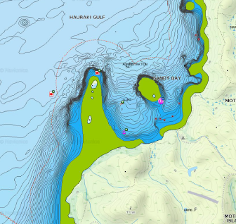
What do you mean offset for tide height? The contours displayed are LAT.
This bit. Does your gear / navionics adjust for height of tide automatically?
Obviously somewhere along the line the depth seen (which is always going to be the depth at LAT plus the current height of tide) needs to be adjusted to a datum (i.e. LAT).
For the chart plotter I was looking at, I was told it would not do that. The Marine Electronics supplier I was talking to (a reputatabe one) stated that there weren't any products that would do I what I wanted (automatically reduce depth to a datum).
-
2 hours ago, Psyche said:
better still if you turn on sonar view on your chartplotter, you will create your own chart overlay that is as accurate and extremely fine grained as your boats sensors will allow.
Tell me about this.
I have been looking at getting a small chart plotter that goes contour charts. (Our current Garmin is a generation too early for this and can't do it). Even the kayak fisho spec units will do 1 ft contours, so I was keen. But when I asked the supplier how to offset for tide height, he says it can't be done. Too much liability for Garmin (or anyone) to do that, or enable doing that.
He continued in saying the market for contours is the fisho crowd, and they are looking for structure. I would be looking for mapping anchorages so I know where I can park, how close in, and where the boogey rocks are. That said, I am developing an interesting in fishing, and it is always fun to know what is below the surface even if you are just sailing.
I've been pondering some way of processing data on a laptop to do my own hydrography, but then I just went sailing and haven't gotten around to it... I assume the Chartplotter data is in some format and extractable. Should just be a field in a gpx file or something. Possibly add the required offset in a gpx file (via csv?) then bung it back in the plotter? A bit of labour, but you would make your own bespoke charts...
-
-
1
-
-
Surprising swell at Stanmore Bay today already. Guess that is how the ancient people forecast storms - unexpected swell in otherwise calm weather.
Metservice and Windy are predicting 3.5 m swell for Hauraki on Sunday. Further north it looks like 4+ m, which will be big for a coast that doesn't normally see swell. I wonder who can spell 'coastal erosion'?
The problem with these storms is the wind always blows out the waves so the surfing is rubbish. Hoping to catch a few in the morning before the easterly kicks in.
-
What I did:
Shakespear park, bird sanctuary - predator proof fence with numerous no dog signs. Young guy took his mongrel dog up to the waterfall. I nearly hit the roof and felt like starting a confrontation. Missus calmed me down and we carried on our walk. We past him on the way back down the path, so I started a pleasant conversation "nice day, lovely spot etc, and then casually, 'oh, you know you aren't allowed dogs in here?' - 'oh, no, really' - 'yeah, their presence scares the kiwi and other rare birds'.
To be fair, straight after, I drove around to the rangers and told him, who promptly picked up his clip board and sped off in his ute.
You can't get into a confrontation, so when the red mist settles, engage in a friendly conversation about the weather or the serenity or something, and quietly slip it in.
It must also be tough for dog owners who want to go away and can't or wont leave their dog behind (I'm not a dog person so don't get this), but that doens't mean rules should be broken. Keeping it on a lead would be good start. Better would be toilet training it on the boat. Just did a week at Kawau. Every night at sunset there would be the procession of dinghys to this one tiny beach that forms as the tide drops, all to take their dog (or cat) for a poo.
-
 1
1
-
-
11 hours ago, Keylime said:
Very hard to use the winch cleats while the sheet is under strain and I’m on the other side of the boat
That is a different question.
If you are single handed and want to be able to control the jib sheet from the windward side (while driving), it is an idea to "cross sheet". As Terry says, use the leeward winch or a turning block to bring the loaded sheet to the windward winch. Then everything is in reach and it may be easier to cleat it off on the winch top.
I've never done this (I can sheet on with the tiller between my legs, and I have big overlappers, so set the headsail and trim the main for balance), but it is a common method in solo sailing. The book that covers all of this stuff is "Single Handed Sailing" by Andrew Evans, who sails 'Foolish Muse'. Andrew is available to chat to on Sailing Anarchy and uses the handle 'Foolish'. Look in the single handed section on Sailing Anarchy.
Singlehanded Sailing : Andrew Evans : 9780071836531 (bookdepository.com)
-
1
-
-
On 24/12/2021 at 12:29 AM, Psyche said:
Turned up in the marina recently, very small indeed
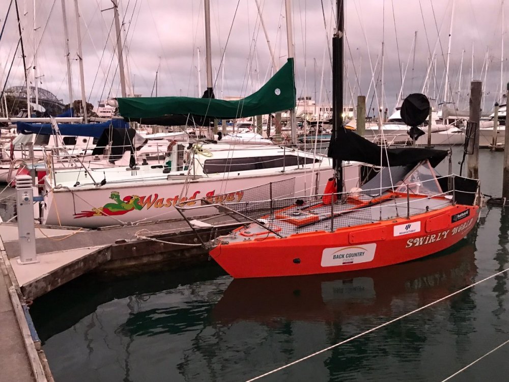
Makes the 930 look like Ross 40
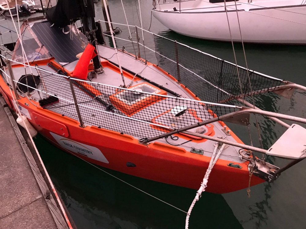
Auckland Islands you say?
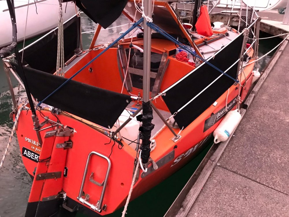
Very practical and sorted
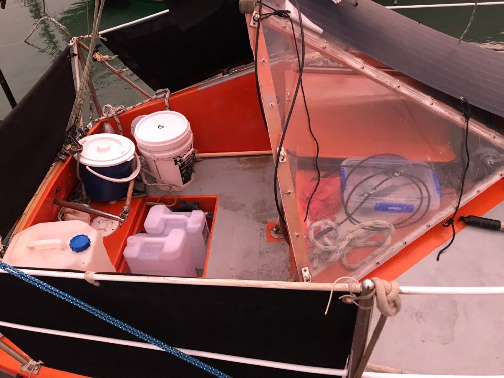
Happy is the man who is content with what he has, why go bigger?
https://boatingnz.co.nz/swirly-waves/
I've just re-read this. You mean in the top photo, the boat next door is a tender, light weight, tippy Ross 930, and the boat infront (Swirlyworld) has been sailed Trans Tasman, to the Kermadecs and to the Auckland Islands, and may very well be sailed around the Southern Ocean passing all 4 Capes?
Faaarrrkkk!
PS, the Ross does look like a 40 in those photos.
-
The random bits on the top of the winch are designed to cleat the rope off to. You can still winch it in when cleated, you just get more turns on the winch. The cam cleats may be faster and easier. but if you are having trouble with them, lock the sheet off on the winch top.
-
2 minutes ago, chariot said:
Sounds like Bon Accord is very full.
Nope, I'm here now, about 1/4 full maybe. Everyone is tucked up along the south side though. Been a little surprised how quiet over the last few days. Max what I would call half full. Full being NY eve rammed full (as in you have to struggle to find space to park up harbour of the yacht club.
-
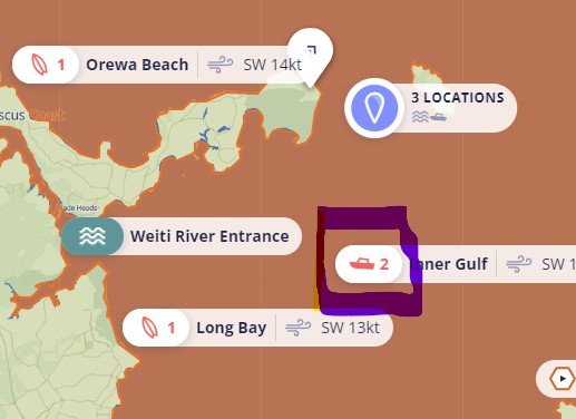
Explainer,
The full 'boating' forecast is as per the link and copied below. You can click on the icon you showed and follow through to this, with 6 hourly prediction for 7 days.
It shows wind, sea and swell. Wind is obvious. 'Sea' is the sea state, i.e. wind waves and chop. Swell is ocean swell, which gives good surfing or not (at a surf beach). Ocean swell is always so long that it isn't an issue for sailing in the Gulf, it can be an issue to make an anchorage rolly, but other than that it isn't a factor, unless you want to go for a surf.
For sea, you've got period, chop height and sea height. I don't actually don't know the difference between sea and chop height. Period is the time in seconds between waves. If it is short, the waves will be steep and 'shitty'. The longer the period the more mello and flatter / smoother the sea will be. The combination of period and height tells you how steep the sea is. If it is really steep, it is nasty, powerful, rolly etc. It is possible to have a high height but a smooth, mello sea if it has a really long period. This is a classic ocean swell that you can sail over all day and not really notice.
Sea below where the period goes from 2-3 sec to 17 sec, that will be when things calm down nicely. Note that the max wind drops off at the same time. Forecast is 'easing' nicely.
Short story, if its been blowing SW for a few days, there is going to be a nasty chop. That is where the size of your boat and your fondness of going 'crash bang' comes into it to make a judgement call.
4AM 10AM 4PM 10PM Sea condition 3323WIND
Max gust (kts) 16 16 19 12 Avg wind speed (kts) 12 13 15 10 Wind direction SW SW SW SW SEA
Period (sec) 2 2 3 17 Chop height (m) 0.3 0.3 0.5 0.3 Sea height (m) 0.4 0.4 0.5 0.3 Sea direction S SW SW SW SWELL
Swell height (m) 0.1 0.2 0.2 0.2 Swell direction S S S NE RATING 7-10: GoodCalm waters, based on little or no wind, and swell height less than a metre.
RATING 4-6: MediumAverage boating conditions, possibly affected by light-fair winds, and a swell height around 1-2 metres.
RATING 1-3: BadPoor and possibly dangerous conditions such as strong winds & a big swell height 2-3+ metres.
NO RATING INFONo rating information is available for the selected time period.
-
1
-
-
1 hour ago, Rgvkiwi said:
Thank you, thats kind of where im leaning.
Picture below shows what I mean about the "dangerous" warning. They say 1-3 dangerous, 4-5 moderate etc...
2 seems squarly in the dangerous zone. Maybe they are factoring the strong winds currently.
I think that 'boating' forecast you have highlighted is more a fishing forecast and indicates comfort in a fizz boat while anchored for fishing. With the current sou wester, the chop will be such that it would be a bit dangerous trying to stand up in a tinnie, bait hooks and drink Lion Red.
The more appropriate marine forecast for your trip is this one: Huaraki Gul Recreational Marine. Swell, as in ocean swell is nothing at the moment, i.e. no good for surfing. Wind driven waves will be moderately high, but going with the wind. If you tried sailing into it in a small boat, it would be a bit tedious. Depending on the size of your boat, going with the wind and waves would be ok. But as per comments, best wait for Saturday, esp if you don't want to frighten your 6 yo or upset the missus.
Hauraki Gulf Recreational Marine Forecast - MetService New Zealand
-
1
-


Bit of weather heading our way?
in MarineTalk
Posted
I check online at 7:30 pm. Saw the first reports of tsunami in Tonga. It specifically said "no threat" to NZ.
Had to put the kids to bed after that and didn't see any cause to go re-checking for alerts when they said there was no threat. Noting that my missus heard the sonic booms and our front door and windows were rattling (that have never rattled in 10 years of living in this house). The news of the eruption explained the rattling.
This issue here is the initial statement saying there was no threat. That was clearly wrong. It is far better to say nothing than to give the wrong answer. If there was no comment on the tsunami threat, I would have checked back latter. Having stated there is no threat, there is no mechanism for many people to then re-check when the govt changes it mind.